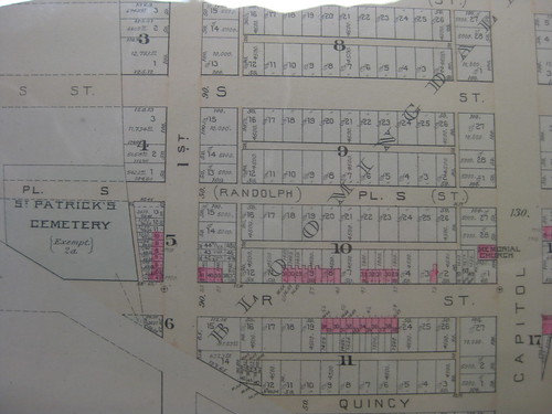
I found this to be very interesting. In the 1897 Real Estate Plat-book, a cemetery is shown at the Northeast corner of Florida Avenue and 2nd St NW. By the 1901 plat-book it no longer existed. Sure, they removed the headstones.......
The land North of Florida Avenue was divided up by subdivisions, the subdivisions were divided by block numbers, and the lot numbers circled the block. The numbers don't correspond to mailing addresses. The pink squares are brick buildings. In most cases you can see that 3 buildings were built per lot.
6 comments:
Sometimes lots change. Your best bet is to use a 20th century map as most housing was built around 1900. Seriously compare the lot numbers between 1897 and say 1903 or 1919.
Also where's you get such a lovely copy? If from teh MLK, how did you deal with the glare?
Wow - this has to be one of the coolest posts in the history of your blog, Scooter.
Couple of things I noticed:
- Our houses used to be on the very edge of Ledroit Park back in the day and were already built back then (which I suspected, given the newsprint from 1901 in the walls). This, of course, brings the question of why DC has such bad data given the amazing amount of records MLK has?
- Fredrick Law Olmstead (one of the most amazing environmental figures in American history)'s McMillan Park is curiously not on these maps and it makes me wonder whether these were just proposed plans as opposed to actual building plats?
Nevertheless - this was an incredible suprise to see. Thanks for posting!
Chris
hey mari,
i used my body to block the lights while taking a picture. it's pretty tricky though.
and yes, most certainly the lots have changed. i was just noting how this map was broken down. lots of bloomingdale was built upon by 1900, and pretty much all by 1919.
chris,
glad you like the map. the librarians told me that the plat-books mapped out the houses that were actually built at the time. that's all i know. what information have you found to be inaccurate?
Thanks for posting this platbook map, Scenic!
wow, that so interesting. thanks for posting!
Post a Comment